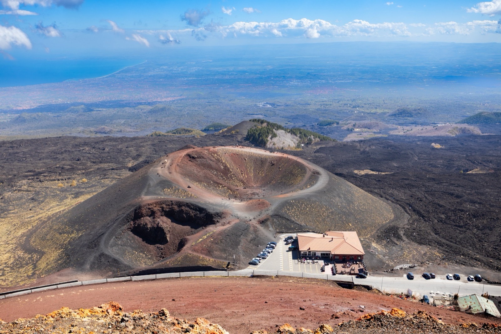
Where Is Mount Etna? Location, Height and How the Volcano Is Laid Out
Mount Etna is on the east coast of Sicily, in southern Italy, just north of the city of Catania. It is not a peak you see from a distance and then travel to: the volcano is so big that Catania, its airport and dozens of towns sit on or around its lower slopes. Its summit stands at roughly 3,350 m, but the exact height changes with every major eruption, and the record measured so far is about 3,369 m, set in July 2024.
This guide explains where Etna is, how big it is, how its height is measured, how the mountain is divided for visitors, and which towns you will pass through on the way up. If you already know where you are going and want driving times, our getting to Etna guide has the routes.
Etna on the map of Sicily
Picture Sicily as a triangle. Etna fills much of the north-eastern corner, rising straight from the Ionian Sea on its eastern side. The Etna DOC wine consortium sums up its position in one line: on the east coast of Sicily, north of Catania.
Three places frame almost every visit:
- Catania, the big city at the volcano’s southern foot. The south-side tourist area at Rifugio Sapienza is about 35 km and 50 minutes by car from here.
- Taormina, the resort town to the north-east. It is about 65 km and 1 hour 30 minutes from the south side, and about 35 km and 55 minutes from the north side.
- The Ionian coast between the two, where towns such as Giarre and Riposto sit almost at sea level with the volcano rising behind them.
UNESCO calls Etna the highest Mediterranean island mountain and the most active stratovolcano in the world, and the park describes it as the highest active volcano in Europe. With a height of about 3,350 m and a base 35 km across, Etna is the largest volcano in Europe.
How big is Etna?
Different public bodies measure Etna in slightly different ways, which is why the numbers vary. Here is how they line up:
| Measure | Figure | Source |
|---|---|---|
| Height | About 3,350 m | Etna Park |
| Area | About 1,260 km² | Etna Park |
| Area covered by its products | About 1,250 km² | Etna Park teaching trail and the UNESCO nomination |
| Boundary of volcanic rock | 250 km | Etna Park |
| Perimeter of the volcanic complex | 135 km | Etna Park teaching trail |
| Base | 35 km across | Civil Protection Department |
| World Heritage site | 19,237 hectares | UNESCO nomination, via the park |
| Etna Park | 59,000 hectares | Etna Park |
The point to take away is the scale. Etna is not one mountain with a few slopes; it is a volcanic massif with its own climate zones, forests, deserts of lava, vineyards and ski runs. The nomination for World Heritage status also called it the largest composite basaltic volcano.
How high is Etna, and why does the number keep changing?
Ask five sources how high Etna is and you can get five answers. They are all honest; they just date from different moments.
- About 3,340 m: the height given in the UNESCO nomination, which made Etna Italy’s highest mountain south of the Alps.
- About 3,350 m: the round figure the Etna Park uses today.
- 3,329 m: the height the park’s teaching trail gives at the North-East Crater.
- 3,357 m: a record reported by INGV in 2021, after about 50 paroxysms at the South-East Crater.
- About 3,369 m: the eastern rim of the Voragine crater, measured by INGV in July 2024, the greatest height ever measured on Etna.
The reason is simple: the summit is made of active craters. Lava fountains build cones up; collapses and explosions knock them down. About a century ago the only crater at the top of Etna was the Central Crater. Today there are four summit craters, and the highest point moves between them. When you read a height for Etna, look for the date beside it.
The summit: four craters, all active
The very top of Etna is not one crater but four:
- The Voragine and the Bocca Nuova, which formed inside the old Central Crater in 1945 and 1968.
- The North-East Crater, which has existed since 1911.
- The South-East Crater, born in 1971 and recently the most active of the four.
Each of the four summit vents is about 200 m across. They are inside the summit zone, which is closed to independent visitors: from 2,920 m at Torre del Filosofo on the south side and from 2,990 m at Punta Lucia on the north side, visits must be accompanied by qualified guides. Our cable car and summit rules guide explains how far you can go on your own.
The Valle del Bove: the great hollow on the east side
Look at a relief map of Etna and one feature jumps out: a huge horseshoe-shaped hollow on the eastern flank. This is the Valle del Bove, and UNESCO’s nomination called it the volcano’s predominant morphological feature, created by a flank that collapsed thousands of years ago.
The park’s figures for it:
- about 18 km round and about 37 km² in area;
- walls to the north and south between 400 and 1,000 m high.
According to the park, most of the recent lava from the South-East Crater has poured into this valley. You can look into it from the rim at Schiena dell’Asino on the south side, or from the Serracozzo viewpoint on the north-east side; both walks are in our Etna hiking guide.
Two sides for visitors: south and north
For a visitor, the most useful map of Etna has only two points on it. Two places on the volcano can be reached freely by car, and everything higher up starts from one of them:
| South side | North side | |
|---|---|---|
| Base | Rifugio Sapienza, 1,910 m | Piano Provenzana, about 1,800 m |
| Town on the way up | Nicolosi | Linguaglossa |
| What starts there | The cable car, the Silvestri craters, most tours | 4x4 excursions, the 2002 craters, the ski lifts |
| Public bus | Daily AST bus from Catania | Only a summer service from Catania, 15 June to 15 September |
The two sides are about 42 km apart, about an hour by car, and are not directly linked: you drive down one side and back up the other. Piano Provenzana’s own comparison gives 60 minutes by car from Taormina to Piano Provenzana and 70 minutes to Rifugio Sapienza, which is why the north side suits a Taormina base.
On the south side, the cable car climbs from 1,920 m to 2,500 m, a 4x4 bus (a snowcat in winter) continues to 2,800 m, and a short guided walk reaches 3,000 m. On the north side, a 4x4 excursion from Piano Provenzana reaches 2,920 m near the Pizzi Deneri observatory.
The towns on Etna’s slopes
Twenty municipalities, home to about 250,000 people, lie inside the Etna Park: Adrano, Belpasso, Biancavilla, Bronte, Castiglione di Sicilia, Giarre, Linguaglossa, Maletto, Mascali, Milo, Nicolosi, Pedara, Piedimonte Etneo, Ragalna, Randazzo, Santa Maria di Licodia, Sant’Alfio, Trecastagni, Viagrande and Zafferana Etnea.
The ones a visitor is most likely to pass through, with the park’s figures for height and distance from Catania:
| Town | Side | Height | From Catania |
|---|---|---|---|
| Trecastagni | South | 586 m | 12 km |
| Nicolosi | South | 700 m | 13 km |
| Zafferana Etnea | East | 574 m | 20 km |
| Milo | East | 720 m | 26 km |
| Giarre | East | 81 m | 30 km |
| Adrano | South-west | 584 m | 33 km |
| Linguaglossa | North-east | 550 m | 44 km |
| Bronte | West | 760 m | 49 km |
| Maletto | North-west | 1,000 m | 58 km |
| Castiglione di Sicilia | North-east | 601 m | 59 km |
| Randazzo | North | 765 m | 69 km |
A few notes on how they fit a visit:
- Nicolosi is the gateway to the south side. The SP92 climbs from here to Rifugio Sapienza.
- Zafferana Etnea sits on the eastern slopes, below the Valle del Bove. The 1991–1993 eruption put the town at risk, and the sunset jeep tour from Catania stops here for local tastings.
- Linguaglossa is the gateway to the north side and Piano Provenzana.
- Randazzo and Castiglione di Sicilia are the old towns of the northern wine country; our Etna wine guide covers them.
Where Etna erupts, and how close the towns are
Being on Etna’s slopes means living with the volcano. Etna erupts both at the summit, where there are currently four craters, and from the flanks, down to a few hundred metres above sea level. That is why the map of Etna’s towns is also a map of its history:
- 1669, Catania. The largest flank eruption documented in historical times opened fissures between about 950 m and 700 m above Nicolosi. Over four months the lava covered 40 square kilometres, reached a maximum length of 17 km, entered Catania on 30 April 1669 and pushed the coastline forward by about 800 metres. The Monti Rossi, the twin cones just north of Nicolosi, were built in that eruption.
- 1928, Mascali. Between 6 and 7 November 1928 the town of Mascali, on the lower eastern flank, was buried by a lava flow. It is the only eruption since the eighteenth century to have destroyed a town on Etna.
- 2002, Piano Provenzana. The lava wiped out the entire tourist station on the north side and stopped only 5 km from the centre of Linguaglossa.
The Civil Protection Department puts it plainly: lava flows can cause material damage but are not a direct threat to the lives of the 900,000 people who live in potentially exposed areas, because they move slowly enough for people to be evacuated. Our Etna eruptions article tells these stories in full.
Etna and Catania airport
Most visitors fly into Catania Fontanarossa, at the volcano’s southern foot. The airport’s position is the reason an eruption can matter even if you never go up the mountain. Ash fall seriously disrupts air traffic and the running of Catania Fontanarossa, Sigonella and Reggio Calabria airports, and when ash falls on the runways the airports close, as often happened at Catania during the 2001 and 2002–2003 eruptions.
It still happens. In late September 2026 Catania airport reopened after three days of stoppage caused by volcanic ash, and the next morning renewed ash from the North-East Crater produced an eruption cloud 4 km high and flights were suspended again. A wind blowing south, towards the airport, weighed on that decision. Italy’s civil aviation authority asks all passengers to check the status of their flight before going to the airport, and our webcams and volcano alerts article explains how to read the warnings.
The park and the World Heritage site
Two different protected areas cover Etna, and they are not the same size.
The Etna Park was the first park set up in Sicily, created by regional decree on 17 March 1987. It covers 59,000 hectares and is divided into four zones with different levels of protection, from the integral reserve (zone A) at the top to the more developed pre-park zones C and D lower down.
The World Heritage site “Mount Etna” was inscribed by UNESCO on 21 June 2013. It covers 19,237 hectares of the park and almost coincides with zone A: the uninhabited high ground. UNESCO says Etna’s eruptive history can be traced back 500,000 years, and that at least 2,700 years of it have been documented. The site holds very little infrastructure, including over 50 small seismic monitoring stations and a scientific observatory.
Etna is also one of the most studied volcanoes on Earth. Sartorius von Waltershausen’s map from the first half of the 19th century was the first geological map of a large volcano.
Etna’s names
You will see the volcano called several things in Sicily. The Greeks called it Aitne, which became Etna. The Arabs called it Djebel-Utlamat, and Sicilians still call it Mungibeddu, or Mongibello, and very often simply “a Muntagna”, the mountain. On menus and wine labels, “Etna” usually means the whole area around the volcano rather than the summit.
Reading a map of Etna
If you are planning walks or drives, a few tips save confusion:
- Use recent maps. Frequent eruptions keep reshaping the ground with new cones and lava fields, so maps on sale may be out of date.
- Look for the two bases. Almost every road on the upper mountain leads to either Rifugio Sapienza or Piano Provenzana.
- The SP92 is the south-side spine. It links Nicolosi with the Rifugio Sapienza area and passes between the two main Silvestri craters.
- Trail numbers are in the 700s. The park numbers its paths, and those numbers appear on signposts on the ground.
How to see Etna’s size for yourself
The best way to understand how big Etna is, is to gain height on it. A few options, from least to most effort:
- The cable car. From 1,920 m to 2,500 m, with the lower cones of the south flank spread out below you. A return ticket for the cable car alone was €54 when checked in September 2026.
- The cable car and 4x4. Up to 2,800 m by 4x4 and a guided walk to about 3,000 m, with the summit craters in view. The operator’s €82 package covers all three stages.
- A sunset tour. The jeep tour from Catania ends with sunset at about 2,000 m, looking out over the coast.
- A summit hike. With a volcano guide, towards the summit craters, which tours advertise as about 3,400 m (a round figure, not a measured height).
You can compare these on our Etna tours page. Before any trip high on the volcano, check the forecast for each level on the Etna weather page, and remember that even in summer it can be cold at altitude.
Frequently asked questions
Which country is Mount Etna in?
Italy. Etna is on the island of Sicily, on its east coast just north of Catania.
How tall is Mount Etna?
About 3,350 m, according to the Etna Park. The exact figure changes with eruptions: INGV measured about 3,369 m at the Voragine crater in July 2024, the greatest height ever measured on Etna.
Is Etna the largest volcano in Europe?
Yes. With a height of about 3,350 m and a base 35 km across, Etna is the largest volcano in Europe, and UNESCO calls it the highest Mediterranean island mountain.
Is Etna near Catania or Taormina?
Both, on different sides. The south-side tourist area is about 35 km from Catania; the north-side area is about 35 km from Taormina.