Hiking on Mount Etna: The Trails You Can Walk, and Where You Need a Guide
Yes, you can hike on Mount Etna without a guide, and some of the best walks on the volcano are short, waymarked and free. The Etna Park keeps a network of numbered trails across every side of the mountain, from a one-hour nature loop in the pines to a 34 km high-level route that takes two or three days. What you cannot do on your own is walk into the summit zone: above 2,920 m on the south side and 2,990 m on the north side, visits to the summit craters must be accompanied by qualified guides.
This guide picks the trails worth knowing, gives the park’s own figures for each (length, climb, time and grade), and explains where the line between independent walking and guided walking falls.
How Etna’s trail network works
The Etna Park describes its trails as running mostly over recent and historic lava flows, through woodland, across bare ground above the tree line and over old farmland, with gradients that change often. That last point matters more than it sounds. A path that looks flat on a map can cross loose volcanic sand, sharp blocky lava and sudden short climbs within a few hundred metres.
A few rules of thumb before choosing a walk:
- Trails are numbered. The park uses numbers in the 700s (737, 704, 723 and so on), and the same numbers appear on signposts and on the park’s own trail pages.
- Each trail has a grade. The park rates them from low (T), through medium (E) and medium-high (E), to high (E or EE). The EE grade is the one to treat with real caution.
- Some trails are closed. Trails the park marks as “not in service” are closed to the public, often because lava or erosion has changed the ground.
- Maps age fast. Frequent eruptions keep reshaping the ground with new cones and lava fields, so maps on sale may be out of date. Check the park’s own trail pages before you go.
The short answer: which walk for which visitor
| Walk | Side | Length | Climb | Time | Park grade |
|---|---|---|---|---|---|
| Silvestri craters | South | Short loop from the car park | Low | 20 minutes to the upper rim | Easy path to the lower crater |
| Monte Nero degli Zappini (782) | South-west | 3 km loop | 130 m | 1 hour | Low (T) |
| Schiena dell’Asino (737) | South-east | 2.54 km | 600 m | 1–2 hours | Medium (E) |
| 2002 craters (guided) | North | About 5 km | 300 m | 2.5–3 hours | Easy to moderate |
| Grotta dei Lamponi – Grotta del Gelo (726) | North-west | 3.35 km | 325 m | 2–3 hours | High (EE) |
| Rifugio Citelli – Serracozzo (723) | North-east | 8 km | 1,080 m | 5–6 hours | Medium-high (E) |
| Canalone della Montagnola (703) | South | 4.7 km | 1,000 m | 2–3 hours | Medium-high (E) |
| Pista Altomontana (701) | West and north | 34 km | 500 m | 2–3 days | Medium (E) |
If you only have half a day and no car, the Silvestri craters next to the cable car are the obvious choice. If you have a car and a few hours, Schiena dell’Asino gives you the biggest view for the least effort. If you want a proper day on foot, Serracozzo or the Canalone della Montagnola are the serious options.
The Silvestri craters: the easiest walk on the volcano
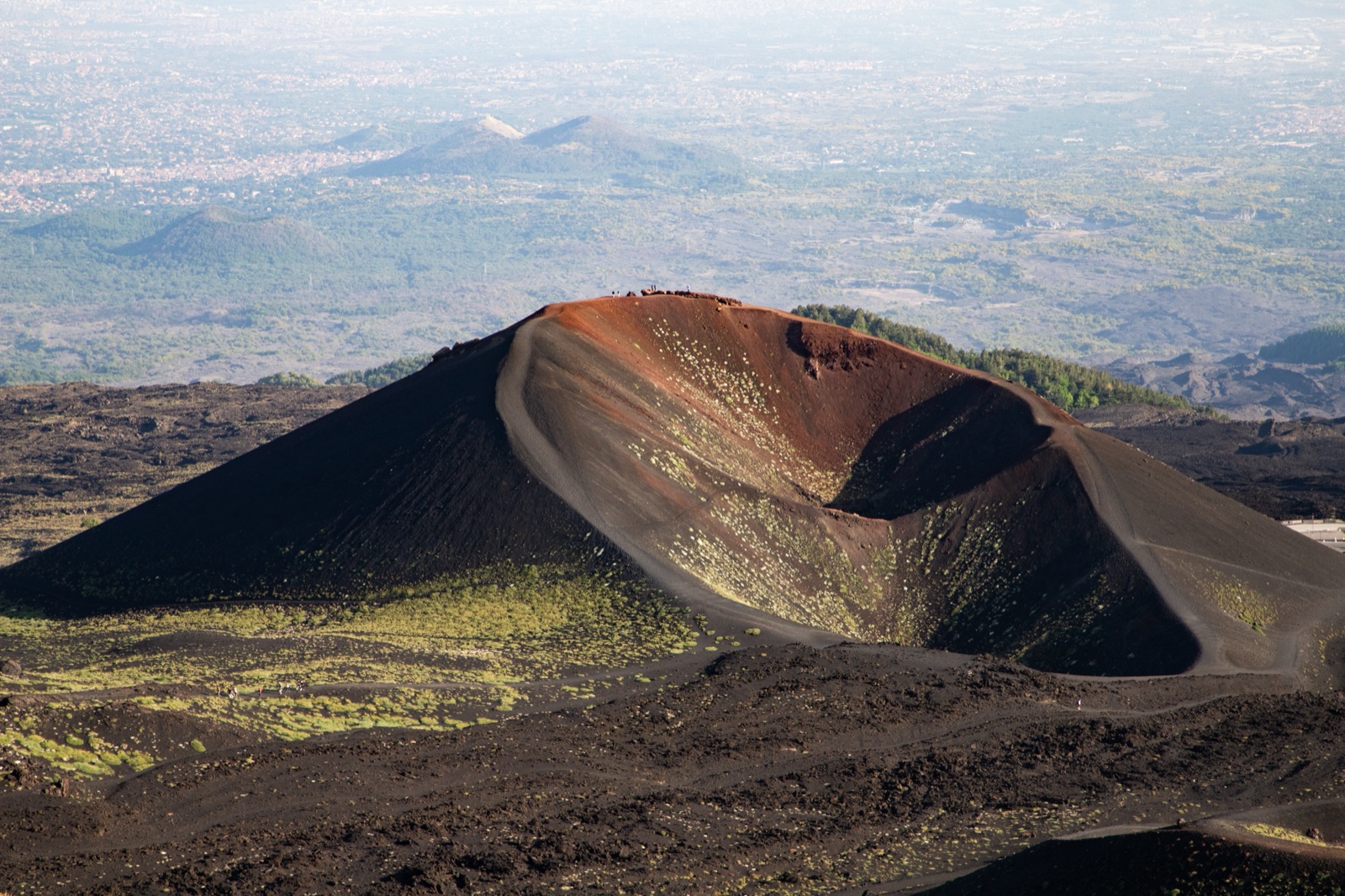
The Silvestri craters sit right beside the Rifugio Sapienza area at the top of the SP92, where the south-side road ends at 1,910 m. They formed in the eruption that began on 9 July 1892, when a fissure opened and five cones grew along it in a line between about 1,800 and 2,025 m. Local people call this kind of row a “bottoniera”, a line of buttons.
There are two main cones, at about 1,900 m:
- The lower crater is usually reached by a fairly simple footpath.
- The upper crater needs a harder climb on loose volcanic ground. A 20-minute walk brings you to its rim.
The SP92 passes between the two main cones, so you can walk straight from the car park or the bus stop. No ticket and no guide are needed. The views on a clear day run down to the Gulf of Catania.
This is also where the AST bus from Catania drops you, so it is the walk most people without a car end up doing. The bus arrives at about 10:15 and leaves Rifugio Sapienza again at 16:30, which leaves plenty of time for the craters, a meal and the cable car if you want to go higher.
Schiena dell’Asino: the rim of the Valle del Bove
If one walk on Etna deserves the drive, it is this one. Schiena dell’Asino, “the donkey’s back”, is a ridge on the edge of the Valle del Bove, the huge horseshoe-shaped depression on the volcano’s eastern side. The name comes from the sandy ground, whose shape recalls a donkey’s back.
Two ways to describe the same walk
There are two sets of figures for this walk, and they describe different things:
- The popular out-and-back walk to the rim. The Nicolosi visitor site describes it as about 5.5 km in all, about 3 hours there and back, with about 200 m of climb. It starts at about 1,850 m, reaches about 2,025 m, and is rated easy to medium in good weather and without snow. You return the same way.
- The park’s full trail 737. The park lists it as 2.54 km with a maximum climb of 600 m, 1–2 hours, graded medium (E). It continues from the rim up past the Malerba memorial stone at 2,040 m to the top of La Montagnola, a huge crater of 1763 at 2,648 m.
Most visitors do the first and turn round at the rim. The view from there takes in the whole north-eastern flank of the volcano and the sheer inner walls of the valley.
Getting to the start
From Rifugio Sapienza, the park’s trail 704 heads east past the upper and lower Silvestri craters and, after about 1 km, reaches a junction at 1,832 m. A track with a barrier across it starts here: that is the Schiena dell’Asino. The first stretch climbs through planted pines on a stony surface, with gradients that can exceed 10%, before the trees open out onto sand and volcanic rock.
When not to go
The park is direct about this: do not walk trail 737 in fog or strong storms that cut visibility. La Montagnola is also a place where lightning strikes often, which is how the hollow glassy rocks called fulgurites form there. If a storm is building in the afternoon, turn back early.
Monte Nero degli Zappini: the easy nature trail
Trail 782 is the gentle option, and it is a good one for families. The park lists it as a 3 km loop with a maximum climb of 130 m, taking about an hour, graded low (T). It was the first nature trail built in Sicily, in mid-1991, and it is still one of the busiest in the park.
It starts on the plateau west of Monte Vetore (1,823 m), a short way from the Grande Albergo dell’Etna, on the road up from Nicolosi. In a single hour it shows you most of what makes Etna’s lower slopes interesting:
- old and recent lava fields, including flows from 1985–2001;
- lava-flow caves and hornitos, the small chimneys built by degassing lava;
- “cannon stones”, sleeves of lava that set round tree trunks;
- big pines, and the Nuova Gussonea botanic garden, before the loop closes back along a short stretch of road.
The park recommends it in spring and autumn rather than in hot summer, or in winter, when sudden snow is common. The caves along it are the Grotta Gussonea, which is closed, and the Grotta di Santa Barbara. There is more on Etna’s caves in our lava caves guide.
The 2002 craters: the north side’s classic walk
On the north side, the walk almost everyone does is the trek from Piano Provenzana to the craters of the 2002 eruption. That eruption began in the night of 26–27 October 2002 and wiped out the entire tourist station of Piano Provenzana; today its craters are one of the most visited sights on the north side.
The guided version run from Piano Provenzana is about 5 km with 300 m of climb, reaching 2,100 m, with 2.5–3 hours on foot. It passes hornitos and climbs the cinder cones of the 2002 “bottoniera” to walk along a crater rim. The operator lists it at €30 for adults (12 and over) and €25 for children aged 5–11, with meeting times of 10.00 or 16.00 and groups of 4–15.
The north side has no cable car, so this kind of walk is the main reason to go there outside the ski season. Piano Provenzana is at about 1,800 m, at the top of the road from Linguaglossa; our getting there guide covers the drive and the lack of public transport.
Serracozzo: a cave, a fissure and a view into the Valle del Bove
For a full, demanding day on the north-east side, trail 723 from Rifugio Citelli is the classic. The park gives it as 8 km with a maximum climb of 1,080 m, 5–6 hours, graded medium-high (E).
What makes it special is how much it packs in:
- The start. It begins on the right just 100 m before Rifugio Citelli, at 1,730 m, and climbs through Etna’s birch woods.
- The cave. After about 20 minutes you reach the Grotta di Serracozzo, formed along a fissure in the 1971 eruption. The entrance is small and needs care, and only people with helmets and torches should go in, for about 50 m.
- The viewpoint. A steep climb then brings you to a balcony over the Valle del Bove at 2,095 m, with magma dykes standing out below like walls.
Strong walkers can go on from 2,150 m to Rocca della Valle (2,738 m) or Pizzi Deneri (2,847 m), but near Rocca della Valle the average gradient approaches 50%. That section is for experienced mountain walkers only.
Grotta del Gelo: the ice cave walk
Trail 726 is the historic route to one of Etna’s oddities: a cave that holds ice all year round. The Grotta del Gelo lies at 2,030 m in a vast field of lava from an eruption that lasted ten years, from 1614 to 1624.
The park lists the trail as 3.35 km with a maximum climb of 325 m, 2–3 hours, and grades it high (EE). It is reached by a path that leaves trail 701 at 1,707 m at Passo dei Dammusi, and it crosses several kinds of lava before reaching the cave. The park gives April–May as the best time for this walk.
It is remote. Getting to the start involves a long approach along the Pista Altomontana, and the terrain is rough. Treat it as a walk for experienced hikers, or go with a guide.
The long routes: Altomontana and the Sentiero Italia
Two park trails are journeys rather than walks:
- Trail 701, the Pista Altomontana (Sentiero Italia). It is 34 km with a maximum climb of 500 m and takes 2–3 days, graded medium (E). It follows a forestry service track at an average height of 1,750 m along the western and northern flanks. Several forestry refuges along the way give walkers shelter. It can be walked in every season, but snow or fog in winter raise the difficulty, and then only experienced, well-equipped walkers should tackle it.
- Trail 704, Piano Vetore – Piano dell’Acqua. About 14 km with a maximum climb of 1,300 m, taking a day, graded medium-high (E). It is the part of the Sentiero Italia that runs along Etna’s south flank, past Rifugio Sapienza and the Silvestri craters and along the edge of the Valle del Bove, using about 2.5 km of the SP92 in short sections.
On the east side, trail 724 runs 27 km from Ballo, near Zafferana Etnea, to Passo Dammusi, with a maximum climb of 1,350 m over 2–3 days. About 45 minutes from the start it passes the Ilice di Carrinu, a holm oak credited with 800 years. Further along, the route passes the Monti Sartorius, a row of cones produced by the 1865 lava flows.
The serious descent: Canalone della Montagnola
Trail 703 is a branch of the summit track that drops into the Valle del Bove. The park lists it as 4.7 km with a maximum climb of 1,000 m, 2–3 hours, graded medium-high (E). It descends about 800 m to the valley floor, at about 1,700 m, down a gully of almost pure volcanic sand.
Two warnings from the park:
- Because the gully is so steep and sandy, the route must be treated as one-way: you go down it, you do not come up it.
- In winter it can be icy and dangerous without proper equipment and technical skill.
This is a walk to do with someone who knows it.
The summit track, and where independent walking stops
Trail 702 is the track to the summit craters. It is a dirt road used by off-road vehicles with specific permits, starting near the cable car station at 1,910 m and circling the summit area at about 3,000 m. The park lists it as 24 km with a maximum climb of 1,200 m, taking a day, graded high (E).
The park says the track can be walked independently when the volcano is in normal activity, but access is set by prefecture and mayoral ordinances, and above heights fixed according to the volcano’s activity, a permitted guide is required. In practice the line has been clear for years:
- South side: since August 2010, ordinances have closed the summit zone from 2,920 m, at Torre del Filosofo, to anyone not with a guide.
- North side: the closed zone starts at 2,990 m, at Punta Lucia.
- Daylight only: where unguided walking is allowed in the summit area, it is only from dawn to sunset, with no bivouacs.
- Guided groups: the ordinances summarised by the volcano guides allow at most 10 people per guide and 400 people a day in the guided zone.
If the summit is what you want, the simplest route is a guided summit hike, which takes the cable car up and then walks towards the summit craters, which tours advertise as about 3,400 m (a round figure, not a measured height). A shorter option is the cable car and 4x4 package that ends with a guided walk to about 3,000 m. Both are explained in our cable car and summit rules guide, and you can compare current options on the tours page.
What to wear and carry on any Etna walk
Etna is a high mountain, even if you drive most of the way up. The Civil Protection Department’s advice to walkers is short: wear a windproof jacket and a cap against the sun, and carry water and food. To that, add:
- Proper shoes. Volcanic sand and blocky lava destroy trainers and twist ankles. Walking boots with a good grip are the minimum.
- Layers. Even in summer it can be cold at altitude. Plan your clothes for the top, not the car park.
- Sun protection. Dark ground, thin air and no shade make the sun strong.
- A head torch. Useful in any lava cave and essential if a walk runs late.
- A charged phone. Signal is patchy, but in an emergency call 112, the European emergency number.
Our when to visit and what to wear guide has a full stage-by-stage packing list.
Weather, cloud and the volcano itself
Two things decide whether a walk is a good idea on the day:
- The weather. Fog and storms are the main danger on open ground like Schiena dell’Asino, and cloud often builds in the afternoon. Check the forecast for the height you are walking at on our Etna weather page, and start early.
- The volcano. Some Etna phenomena are completely unpredictable and sudden, so even at the green alert level the risk is never zero. Before any walk at height, check the latest alerts and ordinances; our webcams and volcano alerts article explains what to look at the evening before.
In bad weather or high volcanic activity, guided excursions are changed or cancelled for safety. If you are walking independently, apply the same rule to yourself.
Frequently asked questions
Can you hike to the top of Etna without a guide?
No. The summit zone is closed to independent visitors above 2,920 m on the south side and 2,990 m on the north side. You can walk many trails below that on your own, but the summit craters need a qualified guide.
What is the easiest walk on Etna?
The Silvestri craters beside Rifugio Sapienza, where the lower crater is reached by a fairly simple path. Monte Nero degli Zappini is the easiest proper trail, a 3 km loop with 130 m of climb.
What is the best half-day hike?
Schiena dell’Asino. About 3 hours there and back on the popular route, with the best view on the south side: straight into the Valle del Bove.
Is hiking on Etna dangerous?
On marked trails below the summit zone, in good weather, the main risks are the ones on any mountain: fog, cold, loose ground and getting lost. The volcano adds a layer of risk that is never zero, which is why the summit area is guided only.